In Part 1 of my PCT gear reviews, I went over the Big Three. In Part 2, I covered cooking, clothing, and hygiene systems. Part 3 will round out everything that’s left.
Electronics
I carried my Samsung Galaxy S5 phone, and it served many functions: phone, wifi, camera, guides, gps, notes, blogging, water reports. It’s a water resistant phone so I didn’t have to worry about having it in a pocket that got sweaty, or getting it out briefly in the rain. I didn’t use a case, so the phone got a few dings from dropping it, but I did later add a screen protector. I carried an aLOKSAK waterproof phone bag to put it in during water crossings, but it never got dunked.
Even though my phone has a camera, I like carrying a real one too. I used a Sony RX100 (they’re up to the fourth version but the first still suits my needs). Its sensor size is about half way between a point and shoot and a DSLR, and it can shoot RAW and manual, so I am able to get some pretty nice photos out of it. I carried it in a Mountainsmith Cyber Small case attached to my pack’s shoulder strap. It’s not waterproof but I’d put it in a ziploc in the case when it rained.
Camera case easily accessible on pack shoulder strap
Once I filled up the 32GB SD card in my camera, I needed to back up my photos, but I was having trouble doing so at the public computers I had access to in trail towns. So I started carrying a SanDisk Ultra Fit CZ43 64GB USB 3.0 Low-Profile Flash Drive to back up photos to. To transfer the files from my SD card to the flash drive, I used a Transcend USB 2.0 OTG Card Reader, which could be plugged into my phone.
To keep my electronics charged, I carried an Anker 10,000 mAh battery pack, an Anker 4-port USB Wall Charger, and several USB cables. The battery pack could charge my phone about three times between towns. Everything stayed in a Sea to Summit 1L Ultra-Sil Dry Sack while I hiked.
I used a SPOT Gen3 device to send out an email to my family with my GPS location every night, for their peace of mind, and so I could see where I camped every night later. It is also an emergency device that could send my GPS location right to 911 if necessary, although I’ve never had to use that feature. The battery life on this is amazing. I’ve had it a year and a half and have yet to change them. The messages go out 99.9% of the time with no problem, which is good enough for just checking in.
Guides
The best guidebook for town planning is Yogi’s PCT Handbook. It has lists of motels, hostels, grocery stores, restaurants, and other hiker friendly businesses. It also lists places that accept mail drops, where fuel is available, and if there are trail angels in town. I liked it for all of that, but the prices listed were usually way off. The book isn’t just for town, it’s for the trail too, but I found it less useful on trail. I don’t need to know where water has been in past years when I have the Water Report telling me where water is currently (hikers can text/email in updates to the water report as they go). I still carried the Yogi pages for the section I was hiking, but I rarely used them except for town.
What I did use on trail as my main guide was Guthook’s app. I could download maps for each section ahead of time so that I didn’t need signal to use it on trail. It has topo maps, elevation profiles, and waypoints all along the way for water, campsites, views, and other points of interest. Each waypoint also has a comment section so that people who use the app can leave notes for others about whether or not the campsite is good, the water is flowing, what conditions the trails are in, etc. The GPS track in the app is a little out of date, but still completely usable.
A man named Halfmile provides free PCT maps, which can be printed reasonably through Yogi. They were just updated this year, and in addition to the PCT, show many popular alternate routes. I started the trail carrying paper maps, but without snow, the trail was always visible and there wasn’t really any need for navigation of that kind, so I stopped carrying them. I could use the maps on Guthook for every day use, although I did download some Halfmile PDF maps to my phone to use for alternates. My phone always had plenty of battery, and I didn’t worry about it malfunctioning since it’s water resistant, so I felt fairly safe not having paper maps on hand.
Halfmile also has a free app to go with the maps, which uses your cell phone’s GPS to tell you where on the map you are, which waypoints are coming up, the distance and elevation change between you and a certain waypoint, or you can simulate a position to see how far things are from somewhere else. I started using the Halfmile app in addition to Guthook on the northern half of the trail since that is where it seemed the most difference was showing in Halfmile’s new GPS track versus Guthook’s older GPS track.
Miscellaneous
I hiked with my trusty Komperdell Explorer Compact Powerlock Trekking Poles. Trekking poles are great for adding speed on flatter sections and stability on steeper or rockier sections. The flick locks are way easier to maintain than twist locks, and aluminum is more durable than carbon fiber, despite the weight penalty. I also much prefer cork handles to foam for comfort. I removed the wrist straps a long time ago. Despite adding some extra oomph when pushing off, without needing to hold onto the handles as tightly, I find they make falling worse as you can’t let go of the poles and they can get tangled in your legs. I also used one of the poles as my tent pole. Multi-functionality!
Yeah, trekking poles!
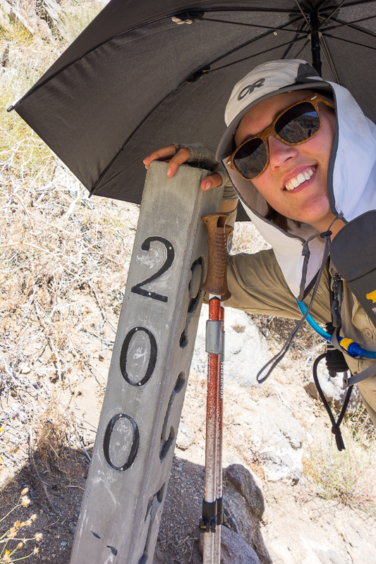
The Liteflex Hiking Chrome Umbrella saved me in the desert. The sun was usually hot enough by 8am that I would pop the umbrella up for some much needed, portable shade for the rest of the day. I also used it to augment the shade of any trees or bushes I could find during breaks. I attached the umbrella to my pack strap using small bungee cords so it could be hands free. That didn’t work in high winds, but when two of the umbrella supports snapped, it was actually in very low wind. Usually the umbrella would just flip inside out in wind, thanks to its flexible supports, but one time it flipped and just kept going, and I couldn’t get it unstrapped from my pack fast enough to stop the stress. Duct fixed it up enough to use on the rest of the trail. I even used the umbrella in rain, since I was already carrying it. It was especially nice in hail since it protected my face and head from getting pummeled.
Hands free umbrella
My Black Diamond Storm Headlamp is waterproof and the light is 160 lumens. I have high brightness standards and this meets them. Stretch refers to it as “The Sun.” If I was doing any amount of night hiking, I’d have to replace the batteries fairly often though. I always kept the light at 100% brightness because I like to be able to see quite a bit, not just a dim area in front of me.
I carried a Ranger CL Compass, although I never had any use for it. If there had been more snow in the Sierra, it’s possible I would have had to navigate with it.
My knife was a small Swiss Army Classic with one blade, nail file, scissors, tweezers, and toothpick. My file is pointed at the end though, and not a screwdriver like the one linked. I used the nail file and the tweezers more than anything. I really have no use for a knife on trail, except sometimes to open food packaging.
The Sea to Summit Mosquito Head Net was a sanity saver in the Sierra. When mosquitoes hit, I was either in my head net, or in my tent.
I carried a Joby GorillaPod as a tripod for my camera. I kept the quick release clip screwed into the bottom of my camera so I could clip it in and out of the tripod quickly. With its flexible legs, I could adjust for levelness on rocks, or wrap the legs right around a tree branch to set up a shot.
My whole first aid / emergency / repair kit fit into a Sea to Summit 1L Ultra-Sil Nano Dry Sack. It consisted of stormproof matches, four spare AAA batteries (for headlamp or SPOT), a Therm-A-Rest patch, needle and thread, SelfGrip athletic tape, Kinesio tape, various sizes gauze pads, various sizes/shapes bandaids, alcohol prep pads, small packets of burn jel, antibiotic ointment, and sting relief, and medicine: antacid, tylenol, ibuprofen, antihistamine, antidiarrheal, and doxycycline. You can see an older version of the kit here. I did not use most of the items in it.
A few other miscellaneous items I always had were a small notebook, a pen, and a small ziploc bag as my wallet (ID, credit, debit, insurance card, and cash).
I did pick up my Kahtoola MICROspikes for the Sierra, but I only used them on Mount Whitney, which is not even on the PCT. They were dead weight the rest of the time, but I’m still glad I had them, if only for peace of mind. There was not enough snow this year that they were really needed, and an ice axe was definitely not needed so I never had mine shipped out.
That’s it!
Any questions on what I used? You can see my complete PCT gear list here.
Leave a Reply